Canals in and around West Midlands - enjoy them!

The West Midlands is at the heart of Britain’s canal network. With hundreds of miles of canals to explore, it’s easy to see why so take our feature and enjoy!


Be happier! Be heathier! Be by the water!

Whether you walk, run, bike or simply sit back and relax by the canal, the more time you spend by water the happier and healthier you feel.   

Photography by Kev Maslin

Photography by Karl Newton


Suggested canal locations to go and experience In Birmingham - enjoy!

There are so many locations along the canal network in and around Birmingham to enjoy.  It may be to experience what it would have been like in days gone by, to make use of the facilities on the canal or to simply take in all that the great outdoors has to offer.

Here's some suggested locations that we have mapped and featured for your enjoyment.


In and around the City


Gas Street Basin - where new meets old! - see map.

The Birmingham Canal Navigations Mainline ends at the start of the Worcester & Birmingham Canal at Gas Street Basin. This was where the Worcester Bar was. Also near here was Old Wharf, where the canal used to continue on what is now the site of Arena Central. Venues here include The Canal House, Canalside Bar and the Tap & Spile. There is also Regency Wharf.

Photography by Hayley Jenkins-Jones


Old Turn Junction

At Old Turn Junction, it is where the Birmingham Canal Navigations Mainline joins onto the Birmingham & Fazeley Canal. When in fact it was the Newhall Branch as far as Cambrian Wharf (Farmers Bridge Locks). Near this junction is the Utilita Arena Birmingham, The Malt House and National Sealife Centre.

Photography by Hayley Jenkins-Jones 

At this location, there is so much to explore and enjoy.  There is Brindleyplace, the Sea-Life Centre, numerous bars, restaurants and cafes, the amazing Ikon Gallery and, not to be missed, the Birmingham Roundhouse

Photography by Hayley Jenkins-Jones


Soho Loop - BCN Old Mainline

The Soho Loop was part of the Birmingham Canal Navigations Old Mainline in the Winson Green area of the city. It goes between Rotton Park Junction and Winson Green Junction, connecting to the straighter Birmingham Canal Navigations New Mainline.

Soho LoopPhotography by Elliott Brown


Selly Oak Winding Hole at the Worcester & Birmingham Canal

Located near Sainsbury's, Unite Student accommodation and the Selly Oak Shopping Centre, at the Bristol Road in Selly Oak is the new Winding Hole. Built for the Lapal Canal Trust during 2022 at the Worcester & Birmingham Canal. There is also a new footbridge that crosses over the canal, and a path that goes under the railway viaduct to the Bristol Road near Bournbrook.

Selly Oak Winding HolePhotography by Elliott Brown


Kings Norton Junction

At Kings Norton Junction, this is where the Worcester & Birmingham Canal meets the Stratford-on-Avon Canal (also called Stratford-upon-Avon Canal). The Kings Norton Junction House is nearby (currently under restoration following a fire). There is walks towards Kings Heath and Yardley Wood in one direction, or towards Stirchley and Bournville in the other direction.

Kings Norton JunctionPhotography by Elliott Brown


Venturing out of the city

Let's now venture out of the city and see what delights can be found along our vast network of canals. 


Birmingham Canal Navigations Mainline - Dudley Port to Sandwell & Dudley

If you get the train from Birmingham New Street to Dudley Port, nearby is the Ryland Aqueduct on the BCN Mainline. Walk as far as you want, the line runs parallel with the Birmingham to Wolverhampton railway line. At one point the canal and railway switches sides. Get off in Sandwell, at either the Albion Bridge or Bromford Bridge, and walk to Sandwell & Dudley Station.

BCN New MainlinePhotography by Elliott Brown


Bumble Hole

Bumble Hole and Warrens Hall Nature Reserve is a stunning location for a leisurely walk to take in some of the amazing history associated with the canals and enjoy the area's bustling wildlife. 

Photography by Daniel Sturley.


Tame Valley Canal

Get the train to Tame Bridge Parkway in Sandwell, to start a walk of the Tame Valley Canal. Once up there you cross over the Grand Junction Aqueduct  (crossing the Birmingham to Walsall railway line) and cross another aqueduct near the M5 and M6 motorways. You can continue walking towards Great Barr. On other walks you can do the section in Perry Barr, or go under Spaghetti Junction in Aston.

Tame Valley CanalPhotography by Elliott Brown


Walsall Canal

You can start a walk on the Walsall Canal from the Walsall Town Basin near New Art Gallery Walsall, and walk as far as the James Bridge Aqueduct. This gets you past the M6 motorway.

Walsall CanalPhotography by Elliott Brown


About the charity Canal & River Trust

The charity, Canal & River Trust, together with dedicated volunteers, do a wonderful job in protecting our canals for everyone to enjoy.

Photography by Damien Walmsley

Photography by Chris Fletcher

This feature is shared with our community and there some great contributions from volunteers and from people who love Birmingham's canals in and around the City.

Photography by Kev Maslin

Go and experience our canals and the great outdoors right on the cities doorstep!


Project dates

03 Apr 2017 - On-going

Passions

History & heritage, Environment & green action, Rivers, lakes & canals
Green travel

Contact

Your Place Your Space

Jonathan Bostock

0121 410 5520
jonathan.bostock@ yourplaceyourspace.com

Related posts

Rivers, lakes & canals
06 Sep 2023 - Elliott Brown
Gallery

Soho Loop Part 2: Asylum Bridge to Winson Green Junction

Post image

On the 31st August 2023, I got the 82 bus to Dudley Road to complete the Soho Loop in Winson Green. Ended up returning via Norman Street Park and rejoining at the Asylum Bridge. Just a short walk to the end of the Soho Loop to Winson Green Junction. That towpath closed on the BCN Mainline to the Winson Green Bridge was open again, it's been tarmaced.

Related

Soho Loop Part 2: Asylum Bridge to Winson Green Junction


On the 31st August 2023, I got the 82 bus to Dudley Road to complete the Soho Loop in Winson Green. Ended up returning via Norman Street Park and rejoining at the Asylum Bridge. Just a short walk to the end of the Soho Loop to Winson Green Junction. That towpath closed on the BCN Mainline to the Winson Green Bridge was open again, it's been tarmaced.


For part 1 follow this link to the post Soho Loop walk on the BCN Old Mainline

From the Costa Coffee at Utilita Arena Birmingham, I walked to the bus stop on Summer Hill Road, waiting for an 87, bus an 82 came first, so caught it up Spring Hill to Dudley Road. Got off and crossed over near City Hospital, then walked up towards Norman Street Park, and got on at the Asylum Bridge, just over a month since I left the Soho Loop in July 2023.


The Asylum Bridge

The Asylum Bridge is on the Revolution Walk from the Canal & River Trust.
Nearby was a Madhouse, Badhouse and the Workhouse. The Birmingham Union Workhouse and Infirmary was there from 1834, but by 1889 had space for over 2000 inmates. This is now part of Birmingham City Hospital.
Also here was the Borough Lunatic Asylum and Fever Hospital, from the 19th century. This is now the site of Birmingham Prison.

dndimg alt="Soho Loop" dndsrc="../uploadedfiles/Soho%20Loop%20BCNOML%2031082023%20(3).JPG" style="width: 100%;" />


Winson Green Prison Bridge and Winson Green Bridge (Soho Loop)

The next bridge is the Winson Green Prison Bridge, which you walk over, followed by the Winson Green Bridge (Soho Loop) which you walk under. This is as close as you get to Birmingham Prison, but you hardly notice it walking past.

dndimg alt="Soho Loop" dndsrc="../uploadedfiles/Soho%20Loop%20BCNOML%2031082023%20(5).JPG" style="width: 100%;" />


Winson Green Bridge (Soho Loop)

There is two bridges named Winson Green Bridge. This one is on the Soho Loop of the BCN Old Mainline. The other one is much higher crossing the BCN New Mainline. This is the last road bridge.

dndimg alt="Soho Loop" dndsrc="../uploadedfiles/Soho%20Loop%20BCNOML%2031082023%20(7).JPG" style="width: 100%;" />


Winson Green Railway Bridge

Next up is the Winson Green Railway Bridge. Behind you can see the yet to open Midland Metropolitan Hospital. When it opens in 2024, parts of City Hospital in Winson Green will close, and the site will be developed for housing.

dndimg alt="Soho Loop" dndsrc="../uploadedfiles/Soho%20Loop%20BCNOML%2031082023%20(10).JPG" style="width: 100%;" />


Winson Green Junction Bridge 

The end of the Soho Loop at Winson Green Junction and you get to the Winson Green Junction Bridge. The bridge is Grade II listed and is a Horseley type cast-iron roving bridge dating to 1828.

dndimg alt="Soho Loop" dndsrc="../uploadedfiles/Soho%20Loop%20BCNOML%2031082023%20(17).JPG" style="width: 100%;" />


Winson Green Roving Bridge

Leaving the Soho Loop at Winson Green Junction, you leave the Old Mainline for the New Mainline. The Winson Green Roving Bridge dates to 1828, and is a Winson Green Roving Bridge is a Horseley type cast-iron roving bridge dating to 1828.

dndimg alt="Winson Green Junction" dndsrc="../uploadedfiles/BCNML%20Winson%20Green%2031082023%20(1).jpg" style="width: 100%;" />


Winson Green Junction

Since my last visit to the canals here, the towpath between Winson Green Roving Bridge and the Winson Green Bridge (Winson Green Road) has been reopened. Last time it was closed for resurfacing works. The Winson Green Junction Bridge is to the left and the northern end of the Soho Loop.

dndimg alt="Winson Green Junction" dndsrc="../uploadedfiles/BCNML%20Winson%20Green%2031082023%20(6).JPG" style="width: 100%;" />


View from the Winson Green Bridge

A look from Winson Green Road, on the Winson Green Bridge towards Winson Green Junction. From here, the Soho Loop starts to the right under the Winson Green Junction Bridge, while the BCN New Mainline continues north west towards Wolverhampton under the Winson Green Roving Bridge.

dndimg alt="Soho Loop" dndsrc="../uploadedfiles/BCNML%20Winson%20Green%2031082023%20(9).JPG" style="width: 100%;" />

Winson Green Road has bus stops for the 11A and 11C. If getting the 11C, it would take you towards Erdington. From the 11A, you can go towards Bearwood, Harborne, Selly Oak, Bournville etc.

You need the Dudley Road for the 82 or 87 bus routes.


Photos by Elliott Brown

Share  Connect with us
90 passion points
Rivers, lakes & canals
24 Aug 2023 - Elliott Brown
Gallery

The changing face of the Digbeth Branch Canal in Eastside

Post image

There is major changes in the area around the Digbeth Branch Canal in Eastside, Birmingham. Between the Ashted Tunnel south eastern entrance and the Curzon Street Tunnel northern entrance. Birmingham City University built there Eastside campus nearby during the 2010s. Now HS2 is underway and Glasswater Locks too.

Related

The changing face of the Digbeth Branch Canal in Eastside


There is major changes in the area around the Digbeth Branch Canal in Eastside, Birmingham. Between the Ashted Tunnel south eastern entrance and the Curzon Street Tunnel northern entrance. Birmingham City University built there Eastside campus nearby during the 2010s. Now HS2 is underway and Glasswater Locks too.


Ashted Tunnel south eastern entrance, Ashted Lock's 2 and 3

The February 2011 view from Belmont Row. There was bulrushes growing next to Ashted Lock no  3. The land towards Lawley Middleway, had probably had demolition on it during the 2000s. Nothing would happen there until 2023!

dndimg alt="Digbeth Branch Canal" dndsrc="../uploadedfiles/DGC%20Eastside%20(Feb%202011)%20(7).JPG" style="width: 100%;" />

By March 2018, on the section towards the Belmont Row Bridge, near Ashted Locks 2 and 3, you could see the completed Birmingham City University buildings, University Locks, Curzon B, and the Curzon Building. The Lock Keepers Cottage was also restored. The towpath entrance / exit to Belmont Row was still open from this side, but still quite narrow. Wide enough for horses and people.

dndimg alt="Digbeth Branch Canal" dndsrc="../uploadedfiles/DBC%20Belmont%20Row%20(Mar%202018)%20(1).JPG" style="width: 100%;" />

By September 2019, half of the brick wall on the right had been demolished, with fencing up. Meanwhile, it was before Belmont Row Works got restored, and you could also see the Unite the Union / Eastside Rooms building (later completed in 2020).

dndimg alt="Digbeth Branch Canal" dndsrc="../uploadedfiles/DBC%20Eastside%20(Sep%202019)%20(4).JPG" style="width: 100%;" />

As of August 2023, Glasswater Locks is under construction between Jennens Road, Lawley Middleway and Penn Street, with the Digbeth Branch Canal on one side. The towpath entrance from the Belmont Row Bridge is closed.

dndimg alt="Digbeth Branch Canal" dndsrc="../uploadedfiles/DGC%20Eastside%2022082023%20(1).jpg" style="width: 100%;" />


Belmont Row Bridge, Ashted Lock's 4 and 5 to Curzon Street Bridge

The view from the Belmont Row Bridge in February 2011. You could clearly see the pool of water to the right of Ashted Lock's 4 and 5. Work on the Curzon Building wouldn't begin to the right until about 2013, two years later. Curzon Street was still visible ahead.

dndimg alt="Digbeth Branch Canal" dndsrc="../uploadedfiles/DGC%20Eastside%20(Feb%202011)%20(2).JPG" style="width: 100%;" />

The new steps from the Digbeth Branch Canal to Belmont Row and University Locks of Birmingham City University was open by September 2019.

dndimg alt="Digbeth Branch Canal" dndsrc="../uploadedfiles/DBC%20Eastside%20(Sep%202019)%20(3).JPG" style="width: 100%;" />

There is a new entrance to the Digbeth Branch Canal from Belmont Row. To the left is student accommodation at University Locks (built 2015-16). To the right is the Curzon Building (built 2013-15), along with Curzon B (built 2016-18), all part of Birmingham City University. Seen during August 2023.

dndimg alt="Digbeth Branch Canal" dndsrc="../uploadedfiles/DGC%20Eastside%2022082023%20(2).jpg" style="width: 100%;" />


Curzon Street Bridge, Ashted Bottom Lock to Curzon Street Tunnel northern entrance

This was what the Digbeth Branch Canal looked like between Curzon Street and the Curzon Street Tunnel in February 2011, long before HS2. There used to be a modern towpath exit up the the road near the railway, above the tunnel, this was open as late as 2018.

dndimg alt="Digbeth Branch Canal" dndsrc="../uploadedfiles/Curzon%20St%20Tunnel%20(Feb%202011)%20(2).JPG" style="width: 100%;" />

There used to be a circular area with benches, close to Curzon Street, as seen below in April 2017. It could have been used to move horses around in a circle with their rope attached to the narrowboat. Also the towpath exit used to lead to the road above the Curzon Street Tunnel. HS2 had closed this off by 2019 or 2020.

dndimg alt="Digbeth Branch Canal" dndsrc="../uploadedfiles/DBC%20Curzon%20St%20(Apr%202017)%20(2).JPG" style="width: 100%;" />

A now impossible shot from September 2018, I went up the towpath to the land above the Curzon Street Tunnel to look at the Birmingham City University buildings beyond Curzon Street. Access up here was still open into 2019, before HS2 eventually hoarded if off. Wasn't much up there, with land fenced off. This was before HS2 demolished the Curzon Gate student accommodation, in the way of the line in 2019.

dndimg alt="Digbeth Branch Canal" dndsrc="../uploadedfiles/DGC%20Curzon%20St%20(Sep%202018)%20(5).JPG" style="width: 100%;" />

By September 2019, the land above the Curzon Street Tunnel had been hoarded off by HS2, although the towpath ramp was still open, it didn't lead anywhere any more, other than above the tunnel.

dndimg alt="Digbeth Branch Canal" dndsrc="../uploadedfiles/DBC%20Eastside%20(Sep%202019)%20(1).JPG" style="width: 100%;" />

As of August 2023, Annatomix is working on finishing her mural for HS2 on the left, not far from the Ashted Bottom Lock. No longer access to the towpath exit above the tunnel now. But the towpath through the tunnel towards Fazeley Street is still open.

dndimg alt="Digbeth Branch Canal" dndsrc="../uploadedfiles/Annatomix%20HS2%20DGCE%2022082023.jpg" style="width: 100%;" />

Photography by Elliott Brown

Share  Connect with us
70 passion points
Rivers, lakes & canals
30 Jul 2023 - Elliott Brown
Gallery

Soho Loop walk on the BCN Old Mainline

Post image

I was going to get onto the Soho Loop at Winson Green Junction, but on the BCN Mainline near Winson Green Road, towpath was closed, so walked down and got on at Rotton Park Junction. Then a minor diversion at the Soho Wharf development before rejoining at Spring Hill. Stayed on the Soho Loop until the Asylum Bridge (although would have gone further). But exited to Norman Street Park.

Related

Soho Loop walk on the BCN Old Mainline


I was going to get onto the Soho Loop at Winson Green Junction, but on the BCN Mainline near Winson Green Road, towpath was closed, so walked down and got on at Rotton Park Junction. Then a minor diversion at the Soho Wharf development before rejoining at Spring Hill. Stayed on the Soho Loop until the Asylum Bridge (although would have gone further). But exited to Norman Street Park.


The Soho Loop opened in 1772, and was part of the Birmingham Canal Navigations Old Mainline and developed by James Brindley. It became a loop when the straighter Birmingham Canal Navigations Mainline, developed by Thomas Telford, opened in 1827. This created two junctions: Rotton Park Junction with the Soho Loop, Icknield Port Loop and the BCN Mainline and Winson Green Junction.


This walk was on Sunday 23rd July 2023.


Rotton Park Junction

Having caught the 11C bus to Summerfield Park, Winson Green, my plans changed when I found the towpath closed at the Winson Green Bridge, so couldn't walk to Winson Green Junction, so instead walked down the BCN Mainline and crossed the Rotton Park Towpath Bridge a Rotton Park Junction to get onto the Soho Loop. Here the skyline has changed, with The Mercian, The Bank towers 1 & 2 and the Cortland Square development on Broad Street. Icknield Port Loop to the right.

dndimg alt="Soho Loop" dndsrc="../uploadedfiles/BCNML%20Winson%20Green%2023072023%20(8).jpg" style="width: 100%;" />


Rotton Park Railway Bridge

View from the new Soho Wharf Footbridge, is the Rotton Park Railway Bridge at Rotton Park Junction. It carries the Birmingham to Wolverhampton railway line. This photo would have been impossible until the new footbridge had been built.

dndimg alt="Soho Loop" dndsrc="../uploadedfiles/Soho%20Wharf%20Soho%20Loop%2023072023%20(10).JPG" style="width: 100%;" />


Soho Wharf Footbridge

Most of the new Soho Wharf development on the left is now open. Also a new footbridge has opened to Spring Hill Wharf. I did walk a bit beyond, but found the towpath to be closed to Spring Hill, so had to double back, and divert off the Soho Loop and Soho Wharf to Dudley Road and Spring Hill.

dndimg alt="Soho Wharf" dndsrc="../uploadedfiles/Soho%20Wharf%20Soho%20Loop%2023072023%20(1).jpg" style="width: 100%;" />


Soho Wharf to Spring Hill

While I did walk a bit of the towpath here, found it to be closed at the Spring Hill Bridge, so had to leave the canal at Soho Wharf over the new footbridge. Street art on the walls to the right.

dndimg alt="Soho Wharf" dndsrc="../uploadedfiles/Soho%20Wharf%20Soho%20Loop%2023072023%20(11).jpg" style="width: 100%;" />


Spring Hill Bridge

A look at the Spring Hill Bridge and Soho Wharf. The towpath on this side was closed. Hopefully it wont be too long before they reopen it to the public.

dndimg alt="Soho Loop" dndsrc="../uploadedfiles/Spring%20Hill%20Soho%20Loop%2023072023%20(2).JPG" style="width: 100%;" />


Spring Hill Pipe Bridge 

Rejoining the Soho Loop at Spring Hill, to walk towards the Black British History is British History sculpture, this was the first bridge back on the canal.

dndimg alt="Soho Loop" dndsrc="../uploadedfiles/Spring%20Hill%20Soho%20Loop%2023072023%20(1).JPG" style="width: 100%;" />


Towards Crabtree Lane

The Soho Loop from Spring Hill to Crabtree Lane. Passed several cyclists around here. Some parkland on the right.

dndimg alt="Soho Loop" dndsrc="../uploadedfiles/Hockley%20Soho%20Loop%2023072023%20(1).JPG" style="width: 100%;" />


Western Road Bridge

The Western Road Bridge carries Crabtree Lane.

dndimg alt="Soho Loop" dndsrc="../uploadedfiles/Hockley%20Soho%20Loop%2023072023%20(2).JPG" style="width: 100%;" />


Towards Hockley Port Junction

This long straight section towards Hockley Port Junction. Lots of trees here, feels very rural.

dndimg alt="Soho Loop" dndsrc="../uploadedfiles/Hockley%20Soho%20Loop%2023072023%20(3).JPG" style="width: 100%;" />


Soho Branch at Hockley Port Junction

The next bridge crosses over at Hockley Port Junction which leads to the Soho Branch and Hockley Port. Private, the gate looked locked, but could see narrowboats down there.

dndimg alt="Soho Loop" dndsrc="../uploadedfiles/Hockley%20Soho%20Loop%2023072023%20(4).JPG" style="width: 100%;" />


Curving round City Hospital

A curved section, City Hospital is on the left (behind the trees). Then had to walk past lots of fishermen!

dndimg alt="Soho Loop" dndsrc="../uploadedfiles/Hockley%20Soho%20Loop%2023072023%20(7).JPG" style="width: 100%;" />


The Wildlife Trusts Birmingham & Black Country

Still passing the fishermen, on the left was The Wildlife Trusts Birmingham & Black Country, part of the Centre of the Earth. Was a boat moored called 'London Poly Roger'.

dndimg alt="Soho Loop" dndsrc="../uploadedfiles/Poly%20Soho%20Loop%2023072023%20(3).JPG" style="width: 100%;" />


Black British History is British History

The reason for this Soho Loop walk was to find this steel sculpture by Luke Perry called 'Black British History is British History'. It was unveiled in 2023. Was also designed by artist Canaan Brown.

dndimg alt="Soho Loop" dndsrc="../uploadedfiles/Black%20BH%20is%20BH%20Soho%20Loop%2023072023%20(1).jpg" style="width: 100%;" />


Asylum Bridge

A look at the Asylum Bridge. Originally I would have walked past it, but I went up onto it to see if it was open (Google Maps said it was closed, I later tried to get Google Maps to change it). Anyway I ended up exiting the Soho Loop here into Norman Street Park.

dndimg alt="Soho Loop" dndsrc="../uploadedfiles/Asylum%20Soho%20Loop%2023072023%20(1).JPG" style="width: 100%;" />


Winson Green Bridge

The view from the Asylum Bridge to the Winson Green Bridge. Was so close to the end of the Soho Loop. That bridge ahead carries another section of Winson Green Road. So will need to go back in future to complete the section to Winson Green Junction.

dndimg alt="Soho Loop" dndsrc="../uploadedfiles/Asylum%20Soho%20Loop%2023072023%20(2).JPG" style="width: 100%;" />


Norman Street Park

There was an Asylum Bridge steel sculpture near the bridge in Norman Street Park. Also this gateway, and a street art wall. Ended up leaving here for the 11A bus stop on Aberdeen Street (not far from City Hospital).

dndimg alt="Soho Loop" dndsrc="../uploadedfiles/Norman%20St%20park%2023072023%20(4).jpg" style="width: 100%;" />


Nearby bus routes include the 11A, 11C, 82 and 87.

Appears to be in walking distance of Jewellery Quarter Station (trains) or Winson Green Outer Circle Tram Stop or Soho Benson Road Tram Stop (trams).


Photos by Elliott Brown

Share  Connect with us
80 passion points
Rivers, lakes & canals
26 Jun 2023 - Elliott Brown
Gallery

Walk up the Tame Valley Canal from Tame Bridge Parkway towards Great Barr

Post image

I got the train to Tame Bridge Parkway Station in Sandwell, and had a walk in the hot weather along part of the Tame Valley Canal. This bit goes near the M5 and M6 motorways. I got off at the Newton Road Bridge in Great Barr (then tried to make my way to Hamstead for the next train to Birmingham). Was probably too hot and humid to do the walk.

Related

Walk up the Tame Valley Canal from Tame Bridge Parkway towards Great Barr


I got the train to Tame Bridge Parkway Station in Sandwell, and had a walk in the hot weather along part of the Tame Valley Canal. This bit goes near the M5 and M6 motorways. I got off at the Newton Road Bridge in Great Barr (then tried to make my way to Hamstead for the next train to Birmingham). Was probably too hot and humid to do the walk.


After arriving at Tame Bridge Parkway Station on Saturday 24th June 2023, left the station via the entrance / exit on the Walsall Road, then headed onto Navigation Lane, to get onto the Tame Valley Canal.


Stonecross Bridge

The Stonecross Bridge, also called Friar Park Bridge or the Walsall Road Bridge. I did not walk in that direction, as was heading to a couple of aqueducts nearby.

dndimg alt="Tame Valley Canal" dndsrc="../uploadedfiles/TVC%20Tame%20Bridge%2024062023%20(3).JPG" style="width: 100%;" />


Navigation Lane Aqueduct

This aqueduct crosses over Navigation Lane, and is Grade II listed. Was built 1841-44.

dndimg alt="Tame Valley Canal" dndsrc="../uploadedfiles/TVC%20Tame%20Bridge%2024062023%20(4).jpg" style="width: 100%;" />


Grand Junction Aqueduct

This aqueduct is near Tame Bridge Parkway Station (opened in 1990). Was built over the Grand Junction Railway (now part of the Birmingham New Street via Perry Barr to Walsall line). Grade II listed, it opened in 1844. There is good views of the station from up here, as well as to the Bescot Yard, Bescot Stadium and The RAC building near the M6 motorway.

dndimg alt="Tame Valley Canal" dndsrc="../uploadedfiles/Grand%20Junction%20Aqueduct%20TVC%2024062023%20(2).jpg" style="width: 100%;" />


M5 Motorway Aqueduct

The next aqueduct crosses over the M5 motorway, to the north west, with it's junction with the M6. The River Tame is also near here, but didn't see it.

dndimg alt="Tame Valley Canal" dndsrc="../uploadedfiles/M5%20Aqueduct%20TVC%2024062023%20(3).jpg" style="width: 100%;" />


River Tame Aqueduct

One more aqueduct, this one crosses over the River Tame. Only had views of the M6 heading in this direction, or the Birmingham skyline and nearby tower blocks.

dndimg alt="Tame Valley Canal" dndsrc="../uploadedfiles/TVC%20aqueduct%20RT%2024062023.jpg" style="width: 100%;" />


Grey Heron

On the section of the Tame Valley Canal beyond the first M5 crossing, saw several grey herons.

dndimg alt="Tame Valley Canal" dndsrc="../uploadedfiles/Grey%20heron%20TVC%2024062023%20(3).JPG" style="width: 100%;" />


Rushall Junction

At this point on the Tame Valley Canal, is Rushall Junction where it joins onto the Rushall Canal. The Rushall Junction Bridge on the left.

dndimg alt="Tame Valley Canal" dndsrc="../uploadedfiles/Rushall%20Jcn%20TVC%2024062023%20(3).JPG" style="width: 100%;" />


Rushall Canal

The start of the Rushall Canal from the Rushall Junction Bridge on the Tame Valley Canal. Bridge in front carries the M6 motorway. Catshill Junction is about 8 miles and 9 locks away on this canal.

dndimg alt="Tame Valley Canal" dndsrc="../uploadedfiles/Rushall%20Canal%20Jcn%2024062023%20(1).JPG" style="width: 100%;" />


Brickfields Bridge

At this point, the towpath switches sides at the Brickfields Bridge. Behind is a pair of M5 motorway bridges, which go from the south west to north east, and join onto the M6. This footbridge is Grade II listed and dates to 1844.

dndimg alt="Tame Valley Canal" dndsrc="../uploadedfiles/M5%20Brickfields%20TVC%2024062023%20(4).JPG" style="width: 100%;" />


M5 Link Road Bridge 1

The first M5 link bridge can be seen from the Brickfields Bridge as you cross it, or as you walk or cycle under it. This is for traffic heading to the end of the M5 and onto the M6 going east.

dndimg alt="Tame Valley Canal" dndsrc="../uploadedfiles/M5%20Brickfields%20TVC%2024062023%20(3).JPG" style="width: 100%;" />


M5 Link Road Bridge 2

The second M5 link bridge. Seen after walking under it. This is for traffic leaving the M6 and heading onto the M5 motorway, heading south west.

dndimg alt="Tame Valley Canal" dndsrc="../uploadedfiles/M5%20Brickfields%20TVC%2024062023%20(5).JPG" style="width: 100%;" />


Brickfields Turnover Bridge

One more Victorian footbridge. Grade II listed, it dates to 1844. Formerly a road bridge apparently. Not sure where it went, but was a man fishing on the other side, and someone with their dog. The Brickfields Turnover Bridge probably links to nearby Chatsworth Avenue.

dndimg alt="Tame Valley Canal" dndsrc="../uploadedfiles/TVC%20Newton%20Rd%2024062023%20(1).JPG" style="width: 100%;" />


Newton Road Bridge

A very high (compared to the canal) road bridge on Newton Road in Great Barr. I took my exit here. Was very hot and sweaty by this point.

dndimg alt="Tame Valley Canal" dndsrc="../uploadedfiles/TVC%20Newton%20Rd%2024062023%20(5).JPG" style="width: 100%;" />


Could of continued to Hamstead and Perry Barr, but left at Great Barr, then tried to get to Hamstead on foot. But at one point caught a no 16 bus to the Scott Arms in Great Barr, before getting another 16 (probably the same one) to Hamstead Station.


In future, maybe best to do these canal walks in cooler weather. It was just too hot and warm. Plus there was the usual illegal off-road motorbikes I encountered on the canal. They were also on a path in a field that lead to Sandwell Valley.


Photography by Elliott Brown

Share  Connect with us
70 passion points
Rivers, lakes & canals
20 Apr 2023 - Elliott Brown
Gallery

Walk on the Walsall Canal from New Art Gallery Walsall to the James Bridge Aqueduct

Post image

On Saturday 15th April 2023, a walk along the Walsall Canal, starting from New Art Gallery Walsall (with a Costa Coffee visit, and look around the gallery first). Then up the Walsall Town Arm, before walking in the direction of the M6 motorway and getting off at the James Bridge Aqueduct. Ended up getting a 39 bus back into Walsall Town Centre, before the train back to Birmingham.

Related

Walk on the Walsall Canal from New Art Gallery Walsall to the James Bridge Aqueduct


On Saturday 15th April 2023, a walk along the Walsall Canal, starting from New Art Gallery Walsall (with a Costa Coffee visit, and look around the gallery first). Then up the Walsall Town Arm, before walking in the direction of the M6 motorway and getting off at the James Bridge Aqueduct. Ended up getting a 39 bus back into Walsall Town Centre, before the train back to Birmingham.


Getting the train from Birmingham New Street to Walsall on Saturday 15th April 2023. New Art Gallery Walsall was minutes walk away from Walsall Station, and at first went to Costa Coffee for a drink, before a look around the gallery. My first visit in around 9 years.

Then after I left the gallery, walked up the Walsall Town Arm, before going onto the Walsall Canal. Aimed to get as far as the M6 motorway at least, and the James Bridge Aqueduct. Was thinking of going a bit further, but it was far enough. Then though about a walk to Bescot Stadium Station, but saw a no 39 bus coming on James Bridge, and caught that back to the Saddlers Shopping Centre for the shortcut into Walsall Station.


New Art Gallery Walsall

View of the Walsall Town Basin at the end of the Walsall Town Arm from an upper level at the New Art Gallery Walsall. Premier Inn hotel with Brewers Fayre restaurant on the right. Behind is the Waterfront retail park, with The Light Cinema Walsall and The Waterfront bar (Hungry Horse). Below on the left is Piri Fino.

dndimg alt="Walsall Canal" dndsrc="../uploadedfiles/NAGW%20Walsall%20Town%20Arm%2015042023%20(4).JPG" style="width: 100%;" />


Walsall Town Arm

The Walsall Town Arm is a short branch off the Walsall Canal to Walsall Town Centre, with modern developments. But just before the basin, appears to be algae at the moment, so not sure if this canal is currently navigable or not. Premier Inn and Brewers Fayre on the left, with Costa Coffee and The New Art Gallery Walsall straight ahead.

dndimg alt="Walsall Town Arm" dndsrc="../uploadedfiles/Walsall%20Town%20Arm%2015042023%20(1).JPG" style="width: 100%;" />


Walsall Locks

Just after the end of the Walsall Town Arm, is the actual Walsall Canal. The Southern Locks of the Walsall Locks is Grade II listed, and is near the Wolverhampton Road Bridge. I did not go that way, but only briefly crossed the Bridgeman Street Bridge to see a mural in full from the other side of the canal.

dndimg alt="Walsall Canal" dndsrc="../uploadedfiles/Walsall%20Locks%20WC%2015042023.JPG" />


Bridgeman Street Bridge

You leave Walsall Town Centre under the Bridgeman Street Bridge. The towpath switches sides here. If you head north, you go to Birchills Junction, where the Walsall Canal joins the Wyrley and Essington Canal. This walk though headed in a south west direction.

dndimg alt="Walsall Canal" dndsrc="../uploadedfiles/Bridgeman%20St%20Bridge%20WC%2015042023%20(2).jpg" style="width: 100%;" />


Rollingmill Street Bridge

The first bridge you pass heading south between Bridgeman Street and Rollingmill Street is the Rollingmill Street Bridge. Just beyond here is Queen Street Cemetery & Sister Dora Gardens.

dndimg alt="Walsall Canal" dndsrc="../uploadedfiles/Rollingmill%20St%20Bridge%20WC%2015042023%20(1).JPG" style="width: 100%;" />


Branch to Old Gas Works

To the left is an old basin, bit of a waste dump, and overgrown now. On the right is an old canal side warehouse building.

dndimg alt="Walsall Canal" dndsrc="../uploadedfiles/BOGW%20Walsall%20Canal%2015042023%20(1).jpg" style="width: 100%;" />


Pagett's Bridge

The next bridge to come across is the Pagett's Bridge. On Pleck Road above is Champy's Bradford Arms.

dndimg alt="Walsall Canal" dndsrc="../uploadedfiles/Pagetts%20Bridge%20WC%2015042023%20(1).JPG" style="width: 100%;" />


Woodward's Bridge

On Woodward's Road is Woodward's Bridge. Near here is a Sikh temple called the Nanaksar Gurdwara. The Pleck Sikh Community Centre is on Wellington Street.

dndimg alt="Walsall Canal" dndsrc="../uploadedfiles/Woodwards%20Bridge%20WC%2015042023%20(2).JPG" style="width: 100%;" />


Scarborough Road Bridge

The last residential bridge is on Scarborough Road, the Scarborough Road Bridge.

dndimg alt="Walsall Canal" dndsrc="../uploadedfiles/Scarborough%20Rd%20Bridge%20WC%2015042023%20(2).jpg" style="width: 100%;" />


Reservoir Place Bridge

Starts to get a bit industrial and derelict, when you get to the Reservoir Place Bridge, with is on Reservoir Place of course. This bridge was built in 1992.

dndimg alt="Walsall Canal" dndsrc="../uploadedfiles/Reservoir%20Pl%20Bridge%20WC%2015042023%20(1).JPG" style="width: 100%;" />


Spinks Bridge

The Spinks Bridge is concrete, and out of use by the looks of it. Development to the right, and getting close to the M6 motorway. South Staffordshire Tramway Generating Station used to be to the left of here.

dndimg alt="Walsall Canal" dndsrc="../uploadedfiles/Spinks%20Bridge%20WC%2015042023%20(1).JPG" style="width: 100%;" />


M6 Motorway Bridge

Getting to the west of Walsall, is the M6 Motorway Bridge, which of course carries the M6 motorway overhead.

dndimg alt="Walsall Canal" dndsrc="../uploadedfiles/M6%20Motorway%20Bridge%20WC%2015042023%20(1).JPG" style="width: 100%;" />


James Bridge Aqueduct

I was aiming to walk at least as far as the James Bridge Aqueduct, although originally thought of going a bit further. The aqueduct was opened in 1797, and is Grade II listed. Below is Bentley Mill Way.

dndimg alt="Walsall Canal" dndsrc="../uploadedfiles/James%20Bridge%20Aq%20WC%2015042023%20(1).jpg" style="width: 100%;" />


Beyond which I did not get to see, was another aqueduct over a railway line, plus a couple more bridges. But the walk was long enough, plus had to see the aqeuduct from road level, and the River Tame was down there. Bus stop was on James Bridge, and got the 39 back into Walsall Town Centre, then went into the Saddlers Shopping Centre, to catch a train back from Walsall to Birmingham New Street.


Photography by Elliott Brown

Share  Connect with us
60 passion points
Rivers, lakes & canals
13 Apr 2023 - Elliott Brown
Gallery

Dudley Port to Sandwell & Dudley canal walk along the BCN New Mainline in Sandwell

Post image

Getting the train up from Birmingham New Street on Good Friday, 7th April 2023 to Dudley Port, near Tipton in Sandwell. The canal towpath access is nearby for the BCN New Mainline, which is high up. A long straight canal developed by Thomas Telford, there is several branches off the canal, and runs alongside the railway. Getting off at Oldbury Road, found the Wednesbury Old Canal as well.

Related

Dudley Port to Sandwell & Dudley canal walk along the BCN New Mainline in Sandwell


Getting the train up from Birmingham New Street on Good Friday, 7th April 2023 to Dudley Port, near Tipton in Sandwell. The canal towpath access is nearby for the BCN New Mainline, which is high up. A long straight canal developed by Thomas Telford, there is several branches off the canal, and runs alongside the railway. Getting off at Oldbury Road, found the Wednesbury Old Canal as well.


Birmingham Canal Navigations New Mainline

This was an afternoon walk from Dudley Port to Sandwell & Dudley via the BCN New Mainline, starting at Dudley Port, near the Ryland Aqueduct, down to the Albion Bridge at Oldbury Road. Could have stayed on to Bromford Road, but found the Wednesbury Old Canal from Albion Road, and walked around past some steel works.


Dudley Port

Getting the train on Good Friday, 7th April 2023 from Birmingham New Street to Dudley Port. The exit is via some steps and a small subway to a car park, and the Dudley Port road. Walking under the Dudley Port Station Bridge and the Ryland Aqueduct, found a towpath access path up to the Birmingham Canal Navigations New Mainline. With this view of Dudley Port Station. Trains are every half an hour in both directions, when I arrived on my train to Wolverhampton, was another train going to Walsall via Birmingham New Street. This is the ideal start for a canal walk on a sunny afternoon.

dndimg alt="Dudley Port" dndsrc="../uploadedfiles/Dudley%20Port%20Station%2007042023%20(13).JPG" style="width: 100%;" />


Ryland Aqueduct

The Ryland Aqueduct crosses the Dudley Port road, and is next to the Dudley Port Station Bridge. There is a view to Dudley in the distance up this road. The no 74 bus between Dudley and Birmingham passes under it.

dndimg alt="BCN New Mainline" dndsrc="../uploadedfiles/Dudley%20Port%20BCN%20NML%2007042023%20(2).JPG" style="width: 100%;" />


Rattlechain Bridge -  Site of Dixon's Basin

This bridge is just after the Ryland Aqueduct. It is cut off, so you can't walk over it, the towpath is to the right of it. The basin was probably behind where the fence is now.

dndimg alt="BCN New Mainline" dndsrc="../uploadedfiles/RB%20SDB%20BCN%20NML%2007042023.JPG" style="width: 100%;" />


Dudley Port Junction

A short walk down from Dudley Port Station and the Ryland Aqueduct, gets you to Dudley Port Junction. Two bridges here, the Dudley Port Junction Bridge and the Dudley Port Roving Bridge, under which is the start of the Netherton Tunnel Branch

dndimg alt="BCN New Mainline" dndsrc="../uploadedfiles/Dudley%20Port%20BCN%20NML%2007042023%20(5).JPG" style="width: 100%;" />


Netherton Tunnel Branch

The Netherton Tunnel Branch is part of the Birmingham Canal Navigations. Starting here at Dudley Port Junction with the BCN New Mainline, it goes towards Windmill End Junction, where it joins onto the BCN Old Mainline. It was built from 1855 and was opened in 1858. One of the last canals to open. The canal was repaired in 1983 and 2013.

dndimg alt="Netherton Tunnel Branch" dndsrc="../uploadedfiles/Netherton%20TB%2007042023%20(1).JPG" style="width: 100%;" />


Rattlechain Bridge and the site of the Rattlechain Brickworks Basin

Another bridge here, and a small pool of water next to the BCN Mainline. Not much to see here now, nature has reclaimed the land here.

dndimg alt="BCN New Mainline" dndsrc="../uploadedfiles/RCB%20BCN%20NML%2007042023%20(3).JPG" style="width: 100%;" />


Dunkirk Toll Island

This is also called  the Dunkirk Stop Island. Narrowboats can go either side of it.

dndimg alt="BCN New Mainline" dndsrc="../uploadedfiles/DTI%20BCN%20NML%2007042023%20(3).JPG" style="width: 100%;" />


Albion Junction

At Albion Junction is the Albion Junction Bridge. It is where you can find the Gower Branch of the Birmingham Canal Navigations.

dndimg alt="BCN New Mainline" dndsrc="../uploadedfiles/Albion%20Jctn%20BCN%20NML%2007042023%20(1).JPG" style="width: 100%;" />


Gower Branch

The Gower Branch Canal starts here at Albion Junction with the BCN New Mainline, and is another part of the Birmingham Canal Navigations. It was authorised in 1768, but was not completed until 1836. It goes towards Brades Hall Junction with the BCN Old Mainline. On the day of this visit, in April 2023, the towpath was closed. The canal lock beyond was probably closed for repairs.

dndimg alt="Gower Branch" dndsrc="../uploadedfiles/Albion%20Jctn%20BCN%20NML%2007042023%20(2).JPG" style="width: 100%;" />


Union Furnace Bridge

This bridge is on Union Road, but is cut off now by the railway. Nearby is William King Ltd. They are a steel stockholder and supplier in West Bromwich.

dndimg alt="BCN New Mainline" dndsrc="../uploadedfiles/Albion%20RB%20BCN%20NML%2007042023%20(1).JPG" style="width: 100%;" />


Albion Railway Bridge

This railway bridge is between Sandwell & Dudley and Dudley Port on the Stour Valley Line, it is at this point that the railway and the BCN New Mainline switch sides.

dndimg alt="BCN New Mainline" dndsrc="../uploadedfiles/Albion%20RB%20BCN%20NML%2007042023%20(3).JPG" style="width: 100%;" />


Albion Bridge

It was a long walk from Dudley Port, and I decided to get off at the Albion Bridge on Oldbury Road, for a walk to the nearest station of Sandwell & Dudley. I would have headed to the right, but headed to the left via Albion Road, and found the nearby Wednesbury Old Canal (see below).

dndimg alt="BCN New Mainline" dndsrc="../uploadedfiles/AB%20BCN%20NML%2007042023%20(2).JPG" style="width: 100%;" />


From the Albion Bridge

I exited at Oldbury Road, on the Albion Bridge, near Oldbury. This was the view from the other side of the bridge. Pudding Green Junction is on the left, and this is the start of the Wednesbury Old Canal (see below). This is the direction towards the Bromford Bridge.

dndimg alt="BCN New Mainline" dndsrc="../uploadedfiles/BCN%20NML%20Albion%20Br%2007042023.JPG" style="width: 100%;" />


From the Bromford Bridge

The Bromford Bridge is on Bromford Road, close to Oldbury, and Bromford Lane in West Bromwich. This is the closest part of the canal to Sandwell & Dudley Station.

dndimg alt="BCN New Mainline" dndsrc="../uploadedfiles/BCN%20NML%20Bromford%20Rd%2007042023.JPG" style="width: 100%;" />


Wednesbury Old Canal

Saw a bit of the Wednesbury Old Canal from Albion Road, on the Izon Bridge. The canal was opened in 1769, but parts abandoned between 1955 and 1960. So only the section between Pudding Green Junction and Ryder's Green Junction is navigable now.


Pudding Green Junction Bridge

This bridge is at Pudding Green Junction, at the start of the Wednesbury Old Canal and the BCN New Mainline.

dndimg alt="Wednesbury Old Canal" dndsrc="../uploadedfiles/Wednesbury%20Old%20Canal%2007042023%20(1).JPG" style="width: 100%;" />


Trident Steel Works Conveyor Bridge

This bridge can be seen from the other side of the Izon Bridge on Albion Road in West Bromwich.

dndimg alt="Wednesbury Old Canal" dndsrc="../uploadedfiles/Wednesbury%20Old%20Canal%2007042023%20(2).JPG" style="width: 100%;" />


Photography by Elliott Brown

Share  Connect with us
60 passion points
Rivers, lakes & canals
17 Nov 2022 - Elliott Brown
Gallery

Selly Oak Winding Hole 2022 update

Post image

The Winding Hole in Selly Oak, near the Bristol Road was built and completed during 2022. At the Worcester & Birmingham Canal, the restoration of the Lapal Canal (Dudley No. 2 Canal) at Selly Oak Junction, which some day in the future will be restored to Halesowen. Until then, the area where narrowboats can turn onto this to be restored canal is now finished. Boats even moor there.

Related

Selly Oak Winding Hole 2022 update


The Winding Hole in Selly Oak, near the Bristol Road was built and completed during 2022. At the Worcester & Birmingham Canal, the restoration of the Lapal Canal (Dudley No. 2 Canal) at Selly Oak Junction, which some day in the future will be restored to Halesowen. Until then, the area where narrowboats can turn onto this to be restored canal is now finished. Boats even moor there.


Previous post from May 2021: Selly Oak Winding Hole until 2021.


During 2022, the Lapal Canal Trust worked to have the Winding Hole built. work was well underway in spring 2022, and was open by autumn 2022. In the future, they will need to dig out the canal under Sainsbury's and next to Selly Oak Shopping Park, towards Harborne Lane and through Selly Oak Park towards Weoley Castle. But that is a long way off for now.

The area, also called Whitehouse Wharf was open on the 25th September 2022 to boats.


May 2021

View from the Worcester & Birmingham Canal, the towpath near an entrance to Selly Oak Shopping Park, as a Cross Country Trains Class 170 passes over the railway. The future Winding Hole site is to the right of here. Seen on the 29th May 2021.

dndimg alt="Selly Oak Winding Hole" dndsrc="../uploadedfiles/XC170%20Selly%20Oak%20Jctn%20(May%202021).jpg" style="width: 100%;" />


August 2021

Views from the passing train on the Cross City Line. There was still grass on the Winding Hole site at the time. View towards the Unite student accommodation with Sainsbury's behind it, on the 15th August 2021.

dndimg alt="Selly Oak Winding Hole" dndsrc="../uploadedfiles/Winding%20Hole%20Selly%20Oak%20(Aug%202021)%20(1).jpg" style="width: 100%;" />

dndimg alt="Selly Oak Winding Hole" dndsrc="../uploadedfiles/Winding%20Hole%20Selly%20Oak%20(Aug%202021)%20(2).jpg" style="width: 100%;" />


January 2022

Early signs that they will soon be digging out the Winding Hole for the Lapal Canal Trust. Seen from the Worcester & Birmingham Canal towpath near the Unite student accommodation on the 8th January 2022.

dndimg alt="Selly Oak Winding Hole" dndsrc="../uploadedfiles/WB%20Canal%20Selly%20Oak%20SP%2008012022.jpg" style="width: 100%;" />


May 2022

By the spring of 2022, work was well underway to dig the grass and soil out of the Winding Hole site, as they secured the site so water didn't get in. Seen from the footbridge that will one day be the entrance to the Lapal Canal (under Sainsbury's) on the 21st May 2022.

dndimg alt="Selly Oak Winding Hole" dndsrc="../uploadedfiles/Winding%20Hole%20Selly%20Oak%20WB%2021052022%20(1).jpg" style="width: 100%;" />

dndimg alt="Selly Oak Winding Hole" dndsrc="../uploadedfiles/Winding%20Hole%20Selly%20Oak%20WB%2021052022%20(2).jpg" style="width: 100%;" />


October 2022

By the autumn of 2022, the Selly Oak Winding Hole was complete, as can be seen from the footbridge and canal towpath. There was even a boat and narrowboat moored at it on the 2nd October 2022.

dndimg alt="Selly Oak Winding Hole" dndsrc="../uploadedfiles/SO%20Winding%20Hole%2002102022%20(1).jpg" style="width: 100%;" />

dndimg alt="Selly Oak Winding Hole" dndsrc="../uploadedfiles/SO%20Winding%20Hole%2002102022%20(2).jpg" style="width: 100%;" />

dndimg alt="Selly Oak Winding Hole" dndsrc="../uploadedfiles/SO%20Winding%20Hole%2002102022%20(3).jpg" style="width: 100%;" />

dndimg alt="Selly Oak Winding Hole" dndsrc="../uploadedfiles/SO%20Winding%20Hole%2002102022%20(4).jpg" style="width: 100%;" />

dndimg alt="Selly Oak Winding Hole" dndsrc="../uploadedfiles/SO%20Winding%20Hole%2002102022%20(5).jpg" style="width: 100%;" />


A couple of weekends later, on the 16th October 2022, this time I got the Selly Oak Winding Hole from the pocket park on the other side of the canal, heading for the Selly Oak Shopping Park via the footbridge that opened in 2021. Two narrowboats moored here this time.

dndimg alt="Selly Oak Winding Hole" dndsrc="../uploadedfiles/SO%20Winding%20Hole%2016102022%20(1).jpg" style="width: 100%;" />

dndimg alt="Selly Oak Winding Hole" dndsrc="../uploadedfiles/SO%20Winding%20Hole%2016102022%20(2).jpg" style="width: 100%;" />

dndimg alt="Selly Oak Winding Hole" dndsrc="../uploadedfiles/SO%20Winding%20Hole%2016102022%20(3).jpg" style="width: 100%;" />


November 2022

I got the train one way from Birmingham New Street to Selly Oak, on the 6th November 2022. Leaving via Bristol Road, it was raining, and saw this view to the Winding Hole. Much more pleasant to see than what it used to look like in the past.

dndimg alt="Selly Oak Winding Hole" dndsrc="../uploadedfiles/Selly%20Oak%20Winding%20Hole%2006112022.jpg" style="width: 100%;" />

Photography by Elliott Brown

Share  Connect with us
60 passion points
Rivers, lakes & canals
24 Aug 2020 - Elliott Brown
Did you know?

The Edgbaston Tunnel on the Worcester & Birmingham Canal

Post image

The Edgbaston Tunnel is located on the Worcester & Birmingham Canal below Church Road in Edgbaston. It is 105 yards long (or 96 metres long). The tunnel runs parallel with the railway tunnel on the Cross City Line. It takes boats about 2 minutes to get through the tunnel. In 2018, the tunnel was closed for months to allow for the towpath to be widened.

Related

The Edgbaston Tunnel on the Worcester & Birmingham Canal


The Edgbaston Tunnel is located on the Worcester & Birmingham Canal below Church Road in Edgbaston. It is 105 yards long (or 96 metres long). The tunnel runs parallel with the railway tunnel on the Cross City Line. It takes boats about 2 minutes to get through the tunnel. In 2018, the tunnel was closed for months to allow for the towpath to be widened.


Edgbaston Tunnel

The Worcester & Birmingham Canal was constructed between 1792 from the Birmingham end, reaching Worcester by 1815. The canal reached Selly Oak by about 1795, so it is fair to assume that the Edgbaston Tunnel was built sometime between 1792 and 1795. Probably dug out by navvies by picks and shovels. Built of red brick, the Edgbaston Tunnel is 96 metres long (105 yards long). It is well under Church Road. Today the closest exits with steps are on Islington Row Middleway (near Five Ways Station) and at The Vale (University of Birmingham student accommodation).

Running parallel with the canal is what is today the Cross City Line. This railway line was built as the Birmingham West Suburban Railway from 1876 until 1885. The Church Road Tunnel was built next to the Edgbaston Tunnel along with a Church Road Station which opened in 1876, not far from the North East Portal of the Edgbaston Tunnel. The station closed in 1925.

Located close to the South West Portal is Hallfield School and near the North East Portal is Sunrise of Edgbaston. When you are up on Church Road, it is a bit hard to see the canal and railway line from above (the brick wall is too high and there is a lot of tree coverage).

During 2018, the Canal & River Trust closed the tunnel, so that they could widen the towpath. This was completed by about May 2018. And now there is more space for cyclists and walkers alike, even with painted lines and "Slow" signs.


2016

First walk through of the Edgbaston Tunnel was during April 2016. I got onto the Worcester & Birmingham Canal at Somerset Road in Edgbaston and walked up the towpath towards Five Ways.

dndimg alt="Edgbaston Tunnel" dndsrc="../uploadedfiles/Edgbaston Tunnel (Apr 2016) (1).jpg" style="width: 100%;" />

Approaching the South West Portal of the Edgbaston Tunnel. To the left is the Cross City Line on the other side of the fence. Above behind all the trees and shrubs is Church Road.

dndimg alt="Edgbaston Tunnel" dndsrc="../uploadedfiles/Edgbaston Tunnel (Apr 2016) (2).jpg" style="width: 100%;" />

Canal & River Trust sign for the Edgbaston Tunnel at the South West Portal. At the time it has space for two way traffic.

dndimg alt="Edgbaston Tunnel" dndsrc="../uploadedfiles/Edgbaston Tunnel (Apr 2016) (3).jpg" style="width: 100%;" />

Nearing the South West Portal of the Edgbaston Tunnel. The towpath inside of the tunnel was quite narrow. So not enough room for both walkers and cyclists at the time.

dndimg alt="Edgbaston Tunnel" dndsrc="../uploadedfiles/Edgbaston Tunnel (Apr 2016) (4).jpg" style="width: 100%;" />

This sign states that the Edgbaston Tunnel is 96 Metres in length (which is quite short).

dndimg alt="Edgbaston Tunnel" dndsrc="../uploadedfiles/Edgbaston Tunnel (Apr 2016) (5).jpg" style="width: 100%;" />

The tunnel was lit up, so when you walk on the towpath, or have a ride on a narrowboat, it is not dark in there.

dndimg alt="Edgbaston Tunnel" dndsrc="../uploadedfiles/Edgbaston Tunnel (Apr 2016) (6).jpg" style="width: 100%;" />

But as you can see, the old tunnel towpath was really too narrow.

dndimg alt="Edgbaston Tunnel" dndsrc="../uploadedfiles/Edgbaston Tunnel (Apr 2016) (7).jpg" style="width: 100%;" />

Up ahead was a couple of narrowboats that were about to enter the tunnel, as well as a person out for a run on the towpath.

dndimg alt="Edgbaston Tunnel" dndsrc="../uploadedfiles/Edgbaston Tunnel (Apr 2016) (8).jpg" style="width: 100%;" />

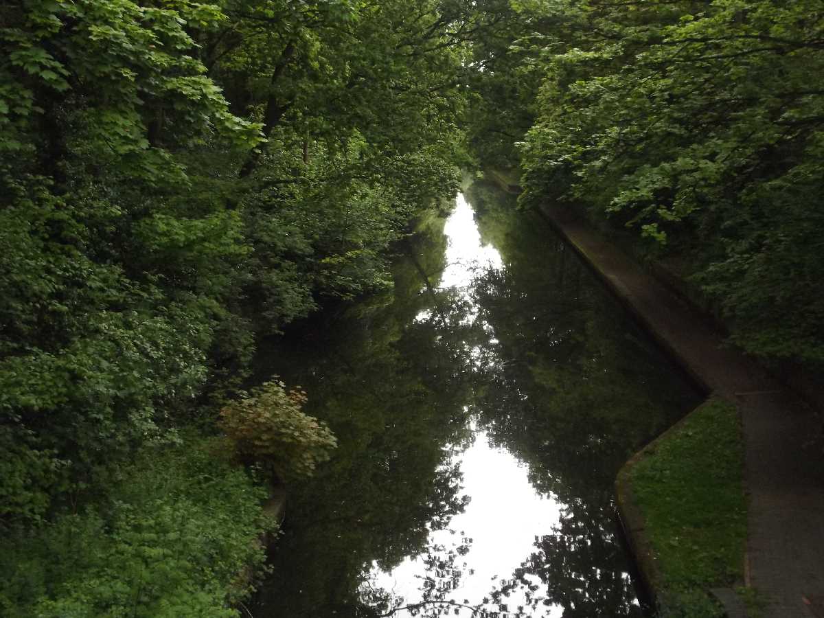
Just as one narrowboat entered the tunnel, to the right you can see the site of the lost Church Road Station.

dndimg alt="Edgbaston Tunnel" dndsrc="../uploadedfiles/W & B Canal Edgbaston Tunnel.jpg" style="width: 100%;" />

Old Georgian and Victorian buildings on Church Road at Hallfield School. The engineering brick on the railway, always seems to get tagged by graffiti vandals. You can also watch passing trains here.

dndimg alt="Edgbaston Tunnel" dndsrc="../uploadedfiles/Edgbaston Tunnel (Apr 2016) (9).jpg" style="width: 100%;" />

2017

The next time I walked through the Edgbaston Tunnel was during November 2017. This walk started from Bath Row and I went as far as The Vale before getting off.

Approaching the North Eastern Portal was this cyclist in an orange jacket.

dndimg alt="Edgbaston Tunnel" dndsrc="../uploadedfiles/Edgbaston Tunnel (Nov 2017) (1).JPG" style="width: 100%;" />

This time I had a better view of the white building above the canal. The building is now occupied by Robert Powell Estate Agents.

dndimg alt="Edgbaston Tunnel" dndsrc="../uploadedfiles/Edgbaston Tunnel (Nov 2017) (2).JPG" style="width: 100%;" />

While the cyclist in orange was riding into the tunnel, saw a narrowboat with all these flat caps and beanies on. Peaky Blinders?

dndimg alt="Edgbaston Tunnel" dndsrc="../uploadedfiles/Edgbaston Tunnel (Nov 2017) (3).JPG" style="width: 100%;" />

Before I entered the Edgbaston Tunnel, saw a London Midland Class 323 train on the Cross City Line entering the Church Road Tunnel.

dndimg alt="Edgbaston Tunnel" dndsrc="../uploadedfiles/Edgbaston Tunnel (Nov 2017) (4).JPG" style="width: 100%;" />

One of the men on the narrowboat was standing on it's roof as it went through the tunnel.

dndimg alt="Edgbaston Tunnel" dndsrc="../uploadedfiles/Edgbaston Tunnel (Nov 2017) (5).JPG" style="width: 100%;" />

Now at the South Eastern Portal of the Edgbaston Tunnel, the gatehouse to Hallfield School is above to the left.

dndimg alt="Edgbaston Tunnel" dndsrc="../uploadedfiles/Edgbaston Tunnel (Nov 2017) (6).JPG" style="width: 100%;" />

Then I saw another London Midland Class 323 entering the tunnel bound for Birmingham New Street and Lichfield Trent Valley.

dndimg alt="Edgbaston Tunnel" dndsrc="../uploadedfiles/Edgbaston Tunnel (Nov 2017) (7).JPG" style="width: 100%;" />

2018

The Edgbaston Tunnel was closed to the public from January to March 2018, so that the Canal & River Trust could widen the towpath, resurface it, and install a new safety railing. There was towpath diversion at the time from Islington Row Middleway to The Vale. By May 2018 it was open again, and I went back to check it out.

This was during a long walk starting at Selly Oak towards Five Ways, Already could see the new towpath extension and railings from the South West Portal.

dndimg alt="Edgbaston Tunnel" dndsrc="../uploadedfiles/Edgbaston Tunnel (May 2018) (1).jpg" style="width: 100%;" />

It was mostly complete, but was still some temporary barriers to the left.

dndimg alt="Edgbaston Tunnel" dndsrc="../uploadedfiles/Edgbaston Tunnel (May 2018) (2).jpg" style="width: 100%;" />

There was a sign for Cyclists Slow as there was a ramp onto the new towpath and it wasn't quite finished.

dndimg alt="Edgbaston Tunnel" dndsrc="../uploadedfiles/Edgbaston Tunnel (May 2018) (3).jpg" style="width: 100%;" />

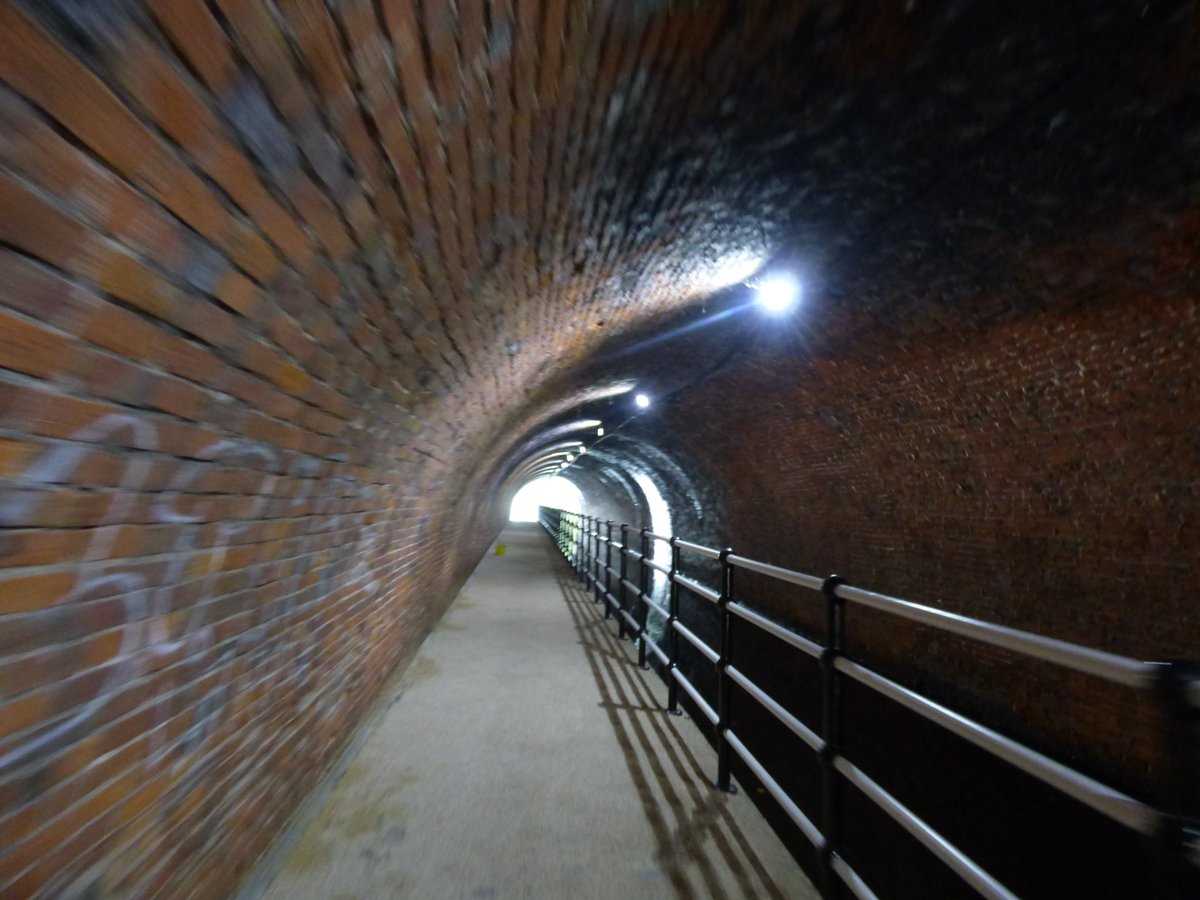
Inside I could see that the towpath was much wider, compared to what it used to be like.

dndimg alt="Edgbaston Tunnel" dndsrc="../uploadedfiles/Edgbaston Tunnel (May 2018) (4).jpg" style="width: 100%;" />

It seems like the tunnel is long, but it isn't, just a trick of the light.

dndimg alt="Edgbaston Tunnel" dndsrc="../uploadedfiles/tunnel elliot.jpg" style="width: 100%;" />

At the North East Portal, a cyclist waits at the Cyclists Slow sign.

dndimg alt="Edgbaston Tunnel" dndsrc="../uploadedfiles/Edgbaston Tunnel (May 2018) (5).jpg" style="width: 100%;" />

Was also a man running through the tunnel, while a builder in yellow and orange overalls was at the other end.

dndimg alt="Edgbaston Tunnel" dndsrc="../uploadedfiles/Edgbaston Tunnel (May 2018) (6).jpg" style="width: 100%;" />

Went back again in December 2018, after the white lines had been painted onto the towpath, and it had all been fully completed.

A cyclist in a yellow jacket heads towards the North East Portal of the Edgbaston Tunnel.

dndimg alt="Edgbaston Tunnel" dndsrc="../uploadedfiles/Edgbaston Tunnel (May 2018) (7).jpg" style="width: 100%;" />

Another cyclist and on the right was a West Midlands Railway Class 323 train on the Cross City Line (passing the site of Church Road Station).

dndimg alt="Edgbaston Tunnel" dndsrc="../uploadedfiles/Edgbaston Tunnel (May 2018) (8).jpg" style="width: 100%;" />

Approaching the Edgbaston Tunnel with the new ramp.

dndimg alt="Edgbaston Tunnel" dndsrc="../uploadedfiles/Edgbaston Tunnel (Dec 2018) (1).jpg" style="width: 100%;" />

Painted on both sides of the ramp was Slow. Pedestrians get priority in the tunnel.

dndimg alt="Edgbaston Tunnel" dndsrc="../uploadedfiles/Edgbaston Tunnel (Dec 2018) (2).jpg" style="width: 100%;" />

Before entering the tunnel, Saw a West Midlands Railway Class 323 train go past, in the new orange and white livery (replacing the old London Midland green).

dndimg alt="Edgbaston Tunnel" dndsrc="../uploadedfiles/Edgbaston Tunnel (Dec 2018) (3).jpg" style="width: 100%;" />

The towpath is now much wider, and even the lighting seems to be brighter in here (not as dark).

dndimg alt="Edgbaston Tunnel" dndsrc="../uploadedfiles/Edgbaston Tunnel (Dec 2018) (4).jpg" style="width: 100%;" />

Slow sign on the ramp close to the South West Portal.

dndimg alt="Edgbaston Tunnel" dndsrc="../uploadedfiles/Edgbaston Tunnel (Dec 2018) (5).jpg" style="width: 100%;" />

And another pair of painted Slow signs closer to the exit of the tunnel.

dndimg alt="Edgbaston Tunnel" dndsrc="../uploadedfiles/Edgbaston Tunnel (Dec 2018) (6).jpg" style="width: 100%;" />

2020

In August 2020, I had my first walk down the Worcester & Birmingham Canal in months (due to the pandemic / lockdown). Starting at The Mailbox and ending at The Vale (was thinking about Somerset Road but The Vale exit came first). Also my first time back in the Edgbaston Tunnel since the end of 2018.

A lady was running towards me, also had to let a couple pass me, due to social distancing.

dndimg alt="Edgbaston Tunnel" dndsrc="../uploadedfiles/Edgbaston Tunnel (Aug 2020) (1).jpg" style="width: 100%;" />

It was a bit hard to see the at white building on Church Road, due to the amount of leaves on the surrounding trees.

dndimg alt="Edgbaston Tunnel" dndsrc="../uploadedfiles/Edgbaston Tunnel (Aug 2020) (2).jpg" style="width: 100%;" />

A narrowboat was coming out of the tunnel.

dndimg alt="Edgbaston Tunnel" dndsrc="../uploadedfiles/Edgbaston Tunnel (Aug 2020) (3).jpg" style="width: 100%;" />

Got this view from just inside of the tunnel as the narrowboat heading out.

dndimg alt="Edgbaston Tunnel" dndsrc="../uploadedfiles/Edgbaston Tunnel (Aug 2020) (4).jpg" style="width: 100%;" />

Still the optical illusion of the tunnel being long (when it isn't).

dndimg alt="Edgbaston Tunnel" dndsrc="../uploadedfiles/Edgbaston Tunnel (Aug 2020) (5).jpg" style="width: 100%;" />

A zoom in from the far end of the tunnel as the narrowboat was still heading on it's way.

dndimg alt="Edgbaston Tunnel" dndsrc="../uploadedfiles/Edgbaston Tunnel (Aug 2020) (6).jpg" style="width: 100%;" />

One last look at the Edgbaston Tunnel as I continued my walk towards The Vale.

dndimg alt="Edgbaston Tunnel" dndsrc="../uploadedfiles/Edgbaston Tunnel (Aug 2020) (7).jpg" style="width: 100%;" />

Photos taken by Elliott Brown.

Follow me on Twitter here ellrbrown.

Share  Connect with us
70 passion points
Rivers, lakes & canals
17 Aug 2020 - Elliott Brown
Did you know?

The Brandwood Tunnel on the Stratford-on-Avon Canal

Post image

One of the oldest structures on the Stratford-on-Avon Canal is the Brandwood Tunnel near Brandwood and Brandwood End in South Birmingham. Located between Kings Heath and Kings Norton, it was built between 1793 and 1796 and opened by 1802. It is over 300 metres long. No towpath inside, so the towpaths go up to road level and you have to find the other end. But it's not signposted.

Related

The Brandwood Tunnel on the Stratford-on-Avon Canal


One of the oldest structures on the Stratford-on-Avon Canal is the Brandwood Tunnel near Brandwood and Brandwood End in South Birmingham. Located between Kings Heath and Kings Norton, it was built between 1793 and 1796 and opened by 1802. It is over 300 metres long. No towpath inside, so the towpaths go up to road level and you have to find the other end. But it's not signposted.


Brandwood Tunnel

The Brandwood Tunnel is on the Stratford-on-Avon Canal in Birmingham. In September 2018 I had a walk of the canal, starting at Alcester Road South near Kings Heath and Alcester Lanes End, and walking towards Kings Norton Junction. It was Birmingham Heritage Week at the time, although my walk here was nothing to do with that.

There is no towpath in the tunnel, so you have to walk up the towpath ramp towards Brandwood Road. And make your way to Shelfield Road for the other end. It was not signposted, and had to check Google Maps at the time (at one point I walked up Monyhull Hall Road in the wrong direction before I turned back and consulted Google Maps).


East Portal of the Brandwood Tunnel

Located on the walk between Alcester Road South and Monyhull Hall Road, is the East Portal of the Brandwood Tunnel. It is a Grade II listed building. It was built from 1793 until 1796 of brick and stone. The canal engineer was probably Josiah Clowes. In an age before motorised narrowboats, the narrowboat would have been pulled by a horse. But the horse would have been taken up to road level, while a pair of men legged it through the tunnel. The towpath leads up to Monyhull Hall Road. You have to walk down Brandwood Park Road to Shelfield Road to get to the other part of the canal, and the West Portal.

dndimg alt="East Portal Brandwood Tunnel" dndsrc="../uploadedfiles/Brandwood Tunnel East Portal (Sept 2018) (1).jpg" style="width: 100%;" />

Was a nice reflection in the water of the tunnel entrance at the east end.

dndimg alt="East Portal Brandwood Tunnel" dndsrc="../uploadedfiles/Brandwood Tunnel East Portal (Sept 2018) (2).jpg" style="width: 100%;" />

Sign about the Brandwood Tunnel at the East Portal. Canoes can go through, but they must check that the tunnel is clear and have a forward facing white light on.

dndimg alt="East Portal Brandwood Tunnel" dndsrc="../uploadedfiles/Brandwood Tunnel East Portal (Sept 2018) (9A).jpg" style="width: 100%;" />

From this point, the towpath starts to go up the hill.

dndimg alt="East Portal Brandwood Tunnel" dndsrc="../uploadedfiles/Brandwood Tunnel East Portal (Sept 2018) (3).jpg" style="width: 100%;" />

Both ends have a portrait, but the East Portal seems to be missing a portrait (maybe it eroded due to weather over 220 plus years?). There was unsightly tags at the top of the East Portal brickwork.

dndimg alt="East Portal Brandwood Tunnel" dndsrc="../uploadedfiles/Brandwood Tunnel East Portal (Sept 2018) (4).jpg" style="width: 100%;" />

The Brandwood Tunnel sign looked like it was in need of a repair.  It's hard to tell who this portrait was of.

dndimg alt="East Portal Brandwood Tunnel" dndsrc="../uploadedfiles/Brandwood Tunnel East Portal (Sept 2018) (5).jpg" style="width: 100%;" />

The Brandwood Tunnel is 322 metres in length.

dndimg alt="East Portal Brandwood Tunnel" dndsrc="../uploadedfiles/Brandwood Tunnel East Portal (Sept 2018) (6).jpg" style="width: 100%;" />

Steps down for someone in a narrowboat to use. Such as the person with the key to the locks.

dndimg alt="East Portal Brandwood Tunnel" dndsrc="../uploadedfiles/Brandwood Tunnel East Portal (Sept 2018) (7).jpg" style="width: 100%;" />

Last look at the East Portal before walking up to the road level. Some more graffiti tags on the right.

dndimg alt="East Portal Brandwood Tunnel" dndsrc="../uploadedfiles/Brandwood Tunnel East Portal (Sept 2018) (8).jpg" style="width: 100%;" />

West Portal of the Brandwood Tunnel

This portal is located near Shelfield Road in Brandwood End. Easy to miss as it was not signposted at road level, so had to check Google Maps to find the towpath. The West Portal is also a Grade II listed building and was built from 1793 to 1794. The north section of the Stratford-on-Avon Canal opened in 1802. This side has a portrait of William Shakespeare (as people in narrowboats will most likely be heading for Shakespeare's Stratford-upon-Avon). Beyond here the canal leads to Kings Norton Junction where it meets the Worcester & Birmingham Canal in Kings Norton (just after a guillotine lock).

dndimg alt="West Portal Brandwood Tunnel" dndsrc="../uploadedfiles/Brandwood Tunnel West Portal (Sept 2018) (1).JPG" style="width: 100%;" />

Heading down the towpath next to the West Portal. More graffiti on the brickwork to the left.

dndimg alt="West Portal Brandwood Tunnel" dndsrc="../uploadedfiles/Brandwood Tunnel West Portal (Sept 2018) (2).JPG" style="width: 100%;" />

First proper glimse at the West Portal of the Brandwood Tunnel, as I headed down the towpath.

dndimg alt="West Portal Brandwood Tunnel" dndsrc="../uploadedfiles/Brandwood Tunnel West Portal (Sept 2018) (3).JPG" style="width: 100%;" />

A view of the portrait of William Shakespeare.

dndimg alt="West Portal Brandwood Tunnel" dndsrc="../uploadedfiles/Brandwood Tunnel West Portal (Sept 2018) (4).JPG" style="width: 100%;" />

This portrait of Shakespeare has survived the centuries, but looks weathered around the edges.

dndimg alt="West Portal Brandwood Tunnel" dndsrc="../uploadedfiles/Brandwood Tunnel West Portal (Sept 2018) (5).JPG" style="width: 100%;" />

Even this side mentions that the Brandwood Tunnel is 322 metres long.

dndimg alt="West Portal Brandwood Tunnel" dndsrc="../uploadedfiles/Brandwood Tunnel West Portal (Sept 2018) (6).JPG" style="width: 100%;" />

One last look at the Shakespeare portrait.

dndimg alt="West Portal Brandwood Tunnel" dndsrc="../uploadedfiles/Brandwood Tunnel West Portal (Sept 2018) (7).JPG" style="width: 100%;" />

A proper look at the West Portal before continuing the walk towards Kings Norton.

dndimg alt="West Portal Brandwood Tunnel" dndsrc="../uploadedfiles/Brandwood Tunnel West Portal (Sept 2018) (8).JPG" style="width: 100%;" />

The Brandwood Tunnel sign at the West Portal at the time was heavily vandalised with graffiti tags. Hopefully the Canal & River Trust has cleaned it up since. But the canal down here always gets tagged, even at the guillotine lock at Kings Norton a bit further down.

dndimg alt="West Portal Brandwood Tunnel" dndsrc="../uploadedfiles/Brandwood Tunnel West Portal (Sept 2018) (9).JPG" style="width: 100%;" />


There are other tunnels that you can walk through. Such as the Edgbaston Tunnel and Broad Street Tunnel on the Worceser & Birmingham Canal, which I can cover in future posts.


Photos taken by Elliott Brown.

Follow me on Twitter here ellrbrown. Thanks for all the followers.

Share  Connect with us
60 passion points
Green travel
17 Apr 2019 - Elliott Brown
Inspiration

A look at the Grand Union Canal from Birmingham to Leamington Spa

Post image

The Grand Union Canal links Birmingham to London, but here we will just look at the areas from Birmingham towards Leamington Spa. Made up of smaller canals bought by the Regents Canal Company in the 1920s. Many locks were widened for double sized barges, although they ended up being used by pairs of narrowboats instead! Through Acocks Green, Olton, Hatton, Warwick and Leamington Spa.

Related

A look at the Grand Union Canal from Birmingham to Leamington Spa


The Grand Union Canal links Birmingham to London, but here we will just look at the areas from Birmingham towards Leamington Spa. Made up of smaller canals bought by the Regents Canal Company in the 1920s. Many locks were widened for double sized barges, although they ended up being used by pairs of narrowboats instead! Through Acocks Green, Olton, Hatton, Warwick and Leamington Spa.


Starting at Spaghetti Junction, below the M6 motorway is Salford Junction. This is where the Grand Union Canal starts in north Birmingham (unless you count Bordesley Junction as the start). At Salford Junction is the Salford Junction Bridge. The canals going left and right is the Tame Valley Canal and the Birmingham & Fazeley Canal. Above is the concrete and graffiti carrying the M6 motorway at the Gravelley Hill Interchange aka Spaghetti Junction. The canal was formerly called the Birmingham & Warwick Junction Canal until it was bought in 1929 by the Regent's Canal company to form the Grand Union Canal. It goes down to Bordesley linking up with the Digbeth Branch of the Grand Union Canal.

dndimg alt="Salford Junction Bridge" dndsrc="../uploadedfiles/Salford Junction Bridge.jpg" style="width: 100%;" />

This April 2018 view of the Grand Union Canal from near the Bordesley Village. Near the Garrison Lane Bridge. Towards The Village Bridge. Graffiti street art for the Canal & River Trust and Phoenix Hall below Bordesley Village. Not far from here is St Andrew's home of Birmingham City FC.

dndimg alt="Bordesley Village - Grand Union Canal" dndsrc="../uploadedfiles/Bordesley Village Grand Union Canal.jpg" style="width: 100%;" />

Near Bordesley Middleway the canal locks that leads onto the Grand Union Canal. The railway bridge of the Snow Hill lines and to the right was the Holy Trinity Church in this view from October 2009. The canal lock is labelled "Bordesley Middle Way no 1". This direction towards Small Heath. Digbeth is back around the loop to the right of here. Time to head off to the suburbs!

dndimg alt="Bordesley Junction - Grand Union Canal" dndsrc="../uploadedfiles/Bordesley Junction Grand Union Canal.JPG" style="width: 100%;" />

Seen near the Westley Vale Millennium Green in Acocks Green. A look at the Grand Union Canal during May 2015. So lush and green at this time of year! The canal down here was the Warwick & Birmingham Canal before becoming part of the Grand Union Canal. Seen from bridge no 86, dating to the late 18th century. Also known as the Woodcock Lane Bridge. This area is not that far from Acocks Green Station.

dndimg alt="Acocks Green - Grand Union Canal" dndsrc="../uploadedfiles/Acocks Green Grand Union Canal Westley Vale.JPG" style="width: 100%;" />

Now the canal heads through Solihull. First a look at the canal in Olton, not far from Olton Station. Seen from the Richmond Road Bridge during January 2013. There had been a bit of snow at this point of the year, but mostly melted. The towpaths can get quite muddy in Solihull!

dndimg alt="Olton - Grand Union Canal" dndsrc="../uploadedfiles/Olton Grand Union Canal.JPG" style="width: 100%;" />

An April 2018 walk from Solihull to Catherine-de-Barnes started at the Damson Parkway Bridge and ended at the Hampton Lane Bridge in Catherine-de-Barnes, a village in Solihull Borough. The towpath was very muddy! Mud on my jeans and shoes! Later took a path back via some fields back to Solihull. A pair of narrowboats seen near the Hampton Lane Bridge, where I got off the muddy towpath to have a look at the village! Yes, it's possible to walk from Solihull Town Centre to Catherine-de-Barnes via the Grand Union Canal!

dndimg alt="Catherine-de-Barnes - Grand Union Canal" dndsrc="../uploadedfiles/Catherine de Barnes Grand Union Canal.jpg" style="width: 100%;" />

Down to Warwickshire now, and the Hatton Locks. This was from a visit to Hatton during March 2017, getting the train from Solihull to Hatton. After exploring the area, I made it eventually to Hatton Locks, what a sight to see from the top! This photo was from around lock 42. The locks are known as the "Stairway to Heaven". This was close to the Hatton Wharf.  St Mary's Church in Warwick was visible from this point. I returned to the Hatton Locks two years later during April 2019 (during my Warwick Station to Warwick Parkway Station walk). That ended near the Hatton Bottom Lock. The canal here was still formerly part of the Warwick & Birmingham Canal, only ending at Budbrooke Junction, near the Saltisford Arm.

dndimg alt="Hatton Locks Grand Union Canal" dndsrc="../uploadedfiles/Hatton Locks Grand Union Canal Hatton.jpg" style="width: 100%;" />

In Warwick from the Coventry Road Bridge. This view of the Grand Union Canal, Kate Boats in Warwick is on the right. Many narrowboats were moored here. My April 2019 walk along the Grand Union Canal in Warwick started from the Coventry Road Bridge, but first a look at the side that I didn't walk up. Got the train to Warwick Station with the intention of walking towards Warwick Parkway Station. The walk takes you past many bridges. The canal here was formerly the Warwick & Napton Canal. It leads to Budbrooke Junction. I got off the canal at the Birmingham Road Bridge and saw the Saltisford Arm, but had to get back on the other side, towards the Hatton Bottom Lock, before getting off again near Warwick Parkway Station!

dndimg alt="Warwick - Grand Union Canal" dndsrc="../uploadedfiles/Warwick Grand Union Canal Kate Boats Warwick.jpg" style="width: 100%;" />

The Grand Union Canal was looking lush and green during May 2016 in Leamington Spa. Train down from Solihull to Leamington Spa. I got onto the towpath at Old Warwick Road and got off at Tachbrook Road. I think at the time I was thinking of getting on at the road I got off, but plans never go to plan when you get to a location to take photos! Here a narrowboat was going at a leisurely pace along the canal, while a man was jogging along the towpath. The canal here is not that far from Leamington Spa Station. Both the canal and the Chiltern Mainline run quite close to each other in Warwickshire!

dndimg alt="Leamington Spa - Grand Union Canal" dndsrc="../uploadedfiles/Leamington Spa Grand Union Canal.jpg" style="width: 100%;" />

Photos taken by Elliott Brown

Follow me on Twitter here ellrbrown (over 1000 followers!).

Share  Connect with us
70 passion points
History & heritage
24 Mar 2019 - Elliott Brown
Inspiration

Birmingham more miles of canals than Venice

Post image

I went to Venice in July 2010 and had a ride on a gondola. We were also taken around the lagoon. A comparison of Birmingham's canals with those in Venice, Italy. Gondolas vs narrowboats. We have more miles of canals in Brum compared to Venice. 35 miles of canals with the City of Birmingham, with most of that navigable. Around 26 miles in Venice. Venice first then a look at Birmingham!

Related

Birmingham more miles of canals than Venice


I went to Venice in July 2010 and had a ride on a gondola. We were also taken around the lagoon. A comparison of Birmingham's canals with those in Venice, Italy. Gondolas vs narrowboats. We have more miles of canals in Brum compared to Venice. 35 miles of canals with the City of Birmingham, with most of that navigable. Around 26 miles in Venice. Venice first then a look at Birmingham!


This post will mostly be a comparison of the Dragon Boat race near Brindleyplace and the narrowboats within the city centre on the Birmingham Canal Navigations near Brindleyplace. With the world famous gondolas seen on the canals in Venice.

We start off with Venice. After the long boat ride to get to the city we got straight onto a gondola for a ride around the famous canals of Venice! The journey starts from the Bacino di San Marco.

dndimg alt="Venice canals - gondolas" dndsrc="../uploadedfiles/Canals in Venice (July 2010) (8).JPG" style="width: 100%;" />

I was on one gondola back in July 2010 and saw this gondola in front! This canal was the Rio di Palazzo. The gondolier's were having a chat with each other!

dndimg alt="Gondola ride on the canals of Venice" dndsrc="../uploadedfiles/Canals in Venice (July 2010) (1).JPG" style="width: 100%;" />

Both gondolas were heading for this footbridge. Many interesting looking buildings on the way!

dndimg alt="Gondola ride on the canals of Venice" dndsrc="../uploadedfiles/Canals in Venice (July 2010) (2).JPG" style="width: 100%;" />

A view of the Hard Rock Cafe in Venice. I can't even recall there being a Hard Rock Cafe in Birmingham! More recently saw a Hard Rock Cafe in Lyon, France and in Florence, Italy. Seen at the Orseolo basin (Bacino Orseolo). The canal might be the Rio del Cappello.

dndimg alt="Hard Rock Cafe near a canal in Venice" dndsrc="../uploadedfiles/Canals in Venice (July 2010) (3).JPG" style="width: 100%;" />

More tourists enjoying a ride on a gondola, like I did earlier that day (a roasting hot 12th July 2010 over 35°C!). This canal was the Rio del Scoa Camini. The Bacino Orseolo (Orseolo Basin) is around the corner.

dndimg alt="Gondola rides on the canals of Venice" dndsrc="../uploadedfiles/Canals in Venice (July 2010) (4).JPG" style="width: 100%;" />

The view from the same footbridge as above, so still the Rio del Scoa Camini. A footpath running alongside the shops. More tourists riding on gondolas. One gondolier on a brake (on the right).

dndimg alt="Gondola rides on the canals of Venice" dndsrc="../uploadedfiles/Canals in Venice (July 2010) (5).JPG" style="width: 100%;" />

Another Venetian canal. Several boats moored on the left. Seen from a footbridge on the Riva degli Schiavoni. This canal is the Rio di San Lorenzo. The bell tower on the right is of the Church of San Giorgio dei Greci (Chiesa di San Giorgio dei Greci in Italian).

dndimg alt="Boats and a tower from a canal in Venice" dndsrc="../uploadedfiles/Canals in Venice (July 2010) (6).JPG" style="width: 100%;" />

If you want a taxi around Venice, then this is the way to travel, by a speedboat! Seen from another footbridge on the Riva degli Schiavoni. This canal was the Rio della Pieta. At this point we were heading to catch a boat for a Lagoon cruise! This might be almost 9 years ago but this day in Venice is still quite memorable!

dndimg alt="Speedboat taxi on a canal in Venice" dndsrc="../uploadedfiles/Canals in Venice (July 2010) (7).JPG" style="width: 100%;" />

OK enough with Venice, and back to Birmingham!

Flowers on the Brindleyplace Bridge over the Birmingham Canal Navigations in this view towards the Broad Street Tunnel. The ICC on the left, Brindleyplace to the right. Flowers out for the 4 Squares Weekender which was held in the city centre over the weekend of the 6th to 8th September 2013 (around when the new Library of Birmingham had opened). The red Waterbus seen behind. And the Sherborne Wharf tourist boat in front!

dndimg alt="4 Squares Weekender 2013 - Brindleyplace bridge" dndsrc="../uploadedfiles/Brindleyplace Bridge on the Birmingham Canal Navigations.jpg" style="width: 100%;" />

Not something you see on the Birmingham Canal Navigations every day. Canoeing on the canal. Saw this in May 2015 close to the Barclaycard Arena (now Arena Birmingham). This view the corner close to the Sealife Centre.

dndimg alt="Canoeing on the BCN" dndsrc="../uploadedfiles/Canoeing on the Birmingham Canal Navigations (1).jpg" style="width: 100%;" />

This view close to the Sheepcote Street Bridge. I also once saw canoes on the Worcester & Birmingham Canal from the Pershore Road Bridge in Stirchley!

dndimg alt="Canoeing on the BCN" dndsrc="../uploadedfiles/Canoeing on the Birmingham Canal Navigations (2).jpg" style="width: 100%;" />

What you are more likely to see around here is a service boat! Seen passing the Waterbus and the Sherborne Wharf tourist narrowboat. It was heading past the Brindleyplace Bridge towards the Broad Street Tunnel during early April 2018. Behind was Arena Birmingham, The Malt House and the Brewmasters House!

See my post on them here The Brasshouse, The Brewmasters House and The Malt House - historic canal buildings around the BCN and Brindleyplace.

dndimg alt="Service boat on the BCN from the Broad Street Tunnel" dndsrc="../uploadedfiles/Service boat on the BCN from Broad Street Tunnel.jpg" style="width: 100%;" />

About a week later (still April 2018), saw this man on a surfboard and a lady on one (might be a canoe)? Well they weren't surfing on the Birmingham Canal Navigations, as they headed under the Brewmasters Bridge. Probably rowing on their boards! This was round about when the BSAVA Congress was on at The ICC (probably not related).

dndimg alt="Surfing or canoeing on the BCN" dndsrc="../uploadedfiles/Surfing on the Birmingham Canal Navigations.jpg" style="width: 100%;" />

OK here's the promised Dragon Boat Race photos. First one from June 2017 outside of the Sealife Centre Birmingham, close to the Brewmasters House and the Brewmasters Bridge. These boats are probably the closest thing we would have in Birmingham to the gondolas in Venice!

dndimg alt="Dragon Boat Race 2017" dndsrc="../uploadedfiles/Dragon Boat Race on the BCN 2017.jpg" style="width: 100%;" />

The Dragon Baot Race  seen during June 2018. Packed full of spectators around the Birmingham Canal Navigations. This was also close to the Sealife Centre Birmingham.

dndimg alt="Dragon Boat Race 2018" dndsrc="../uploadedfiles/Dragon Boat Race on the BCN 2018 (1).jpg" style="width: 100%;" />

Now a building at Brindleyplace that wouldn't be out of place in Venice. Three Brindleyplace is seen to the left of the Sealife Centre. Teams at the race getting ready to race up and down from the Sealife Centre to the Broad Street Tunnel and back. I was only passing through, so didn't see much of the race in 2017 and 2018.

dndimg alt="Dragon Boat Race 2018" dndsrc="../uploadedfiles/Dragon Boat Race on the BCN 2018 (2).jpg" style="width: 100%;" />


Photos taken by Elliott Brown. The day trip to Venice was during July 2010.

Share  Connect with us
80 passion points
Close and return